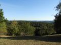
In der zweiten Streckenhälfte stößt man auf einige historische Bauten und Denkmäler. Der Weg ist nicht speziell markiert (zwischen Hagelloch und Waldhausen Markierungen des Schwäbischen Albvereins) und kann natürlich auch in umgekehrter Richtung und in Teilabschnitten begangen werden; Anfangs- und Endpunkt sowie Zwischenstationen sind gut mit dem TÜ-Bus erreichbar.
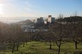
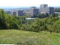
Desweiteren bietet sich ein Wegabschnitt im Westen an, der in der Karte noch nicht eingezeichnet ist: vom Bogentor am Waldrand nach Westen zum Wasserhochbehälter, dann nach Süden Richtung Ebenhalde am westlichen Rand von Hagelloch vorbei über den Sportplatzweg und die Kreuzbergsteige allmählich hinunter durch Wald und Streuobstwiesen ins Ammertal. Die Kuppe des Kreuzbergs wird von gleichnamigem Feldweg umrahmt der unten zur B 296 Herrenberger Straße oder zum Hagellocher Weg führt wo man zu den Bushaltestellen Weilerhalde und Vor dem Kreuzberg gelangt.
Die Karte wird geladen …
{"minzoom":false,"maxzoom":false,"mappingservice":"leaflet","width":"100%","height":"600px","centre":{"text":"","title":"","link":"","lat":48.534226,"lon":9.044151,"icon":""},"title":"","label":"","icon":"","lines":[{"text":"","title":"","link":"","strokeColor":"#FF8C35","strokeOpacity":"1","strokeWeight":"2","pos":[{"lat":48.545414,"lon":9.052316},{"lat":48.545606,"lon":9.05297},{"lat":48.545626,"lon":9.053825},{"lat":48.545015,"lon":9.055327},{"lat":48.544958,"lon":9.056164},{"lat":48.544646,"lon":9.056336},{"lat":48.544518,"lon":9.055864},{"lat":48.544333,"lon":9.056078},{"lat":48.544077,"lon":9.055928},{"lat":48.543893,"lon":9.056164},{"lat":48.544006,"lon":9.056722},{"lat":48.543807,"lon":9.057087},{"lat":48.54402,"lon":9.057494},{"lat":48.54383,"lon":9.057852},{"lat":48.54385,"lon":9.05964},{"lat":48.543883,"lon":9.060329},{"lat":48.543805,"lon":9.060554},{"lat":48.543535,"lon":9.060618},{"lat":48.543528,"lon":9.061423},{"lat":48.543165,"lon":9.061434},{"lat":48.542867,"lon":9.061283},{"lat":48.542377,"lon":9.061412}]},{"text":"","title":"","link":"","strokeColor":"#FF8C35","strokeOpacity":"1","strokeWeight":"2","pos":[{"lat":48.541131,"lon":9.063345},{"lat":48.540873,"lon":9.063494},{"lat":48.54062,"lon":9.063667},{"lat":48.540236,"lon":9.063774},{"lat":48.540099,"lon":9.063451},{"lat":48.539779,"lon":9.063644},{"lat":48.539822,"lon":9.064073},{"lat":48.539772,"lon":9.064352},{"lat":48.539197,"lon":9.065178},{"lat":48.539149,"lon":9.065448},{"lat":48.539078,"lon":9.06563},{"lat":48.538707,"lon":9.065768},{"lat":48.538231,"lon":9.06579},{"lat":48.538018,"lon":9.065908},{"lat":48.537868,"lon":9.066101},{"lat":48.537797,"lon":9.066455},{"lat":48.537819,"lon":9.066712},{"lat":48.537932,"lon":9.066916},{"lat":48.538131,"lon":9.067013},{"lat":48.53833,"lon":9.067066},{"lat":48.538344,"lon":9.067571},{"lat":48.538275,"lon":9.068087}]},{"text":"","title":"","link":"","strokeColor":"#FF8C35","strokeOpacity":"1","strokeWeight":"2","pos":[{"lat":48.542218,"lon":9.062133},{"lat":48.542443,"lon":9.062914},{"lat":48.542635,"lon":9.064255},{"lat":48.54267,"lon":9.065028},{"lat":48.542869,"lon":9.065328},{"lat":48.54277,"lon":9.065714},{"lat":48.542523,"lon":9.065909},{"lat":48.542239,"lon":9.066027},{"lat":48.542026,"lon":9.065974},{"lat":48.541785,"lon":9.065748},{"lat":48.541406,"lon":9.065543},{"lat":48.541221,"lon":9.065318},{"lat":48.540795,"lon":9.065264},{"lat":48.540435,"lon":9.065276}]},{"text":"","title":"","link":"","strokeColor":"#FF0000","strokeOpacity":"1","strokeWeight":"2","pos":[{"lat":48.543688,"lon":9.009991},{"lat":48.544597,"lon":9.010634},{"lat":48.545535,"lon":9.011793},{"lat":48.546218,"lon":9.011829},{"lat":48.546957,"lon":9.013546},{"lat":48.547566,"lon":9.014668},{"lat":48.547794,"lon":9.015806},{"lat":48.547752,"lon":9.017279},{"lat":48.548504,"lon":9.019475},{"lat":48.548419,"lon":9.020956},{"lat":48.547978,"lon":9.02132},{"lat":48.547552,"lon":9.023509},{"lat":48.547751,"lon":9.026384},{"lat":48.548092,"lon":9.029517},{"lat":48.547566,"lon":9.033015},{"lat":48.546188,"lon":9.033616},{"lat":48.544286,"lon":9.033973},{"lat":48.542695,"lon":9.033115},{"lat":48.541275,"lon":9.031913},{"lat":48.54099,"lon":9.032943},{"lat":48.542042,"lon":9.034874},{"lat":48.541927,"lon":9.036813},{"lat":48.542026,"lon":9.038057},{"lat":48.542411,"lon":9.039338},{"lat":48.543816,"lon":9.042392},{"lat":48.544372,"lon":9.042299},{"lat":48.54447,"lon":9.046919}]},{"text":"","title":"","link":"","strokeColor":"#FF0000","strokeOpacity":"1","strokeWeight":"2","pos":[{"lat":48.544512,"lon":9.046962},{"lat":48.545336,"lon":9.049044},{"lat":48.545421,"lon":9.052262},{"lat":48.542296,"lon":9.05252},{"lat":48.538517,"lon":9.054086},{"lat":48.538461,"lon":9.05449},{"lat":48.537672,"lon":9.054354},{"lat":48.537437,"lon":9.055191},{"lat":48.537345,"lon":9.056103},{"lat":48.537352,"lon":9.057155},{"lat":48.53711,"lon":9.056919},{"lat":48.53687,"lon":9.056422},{"lat":48.536244,"lon":9.056808},{"lat":48.536088,"lon":9.056743},{"lat":48.535491,"lon":9.057087},{"lat":48.534966,"lon":9.056872},{"lat":48.53488,"lon":9.057409},{"lat":48.534468,"lon":9.057881},{"lat":48.534568,"lon":9.058288},{"lat":48.534795,"lon":9.058675},{"lat":48.53525,"lon":9.058889},{"lat":48.535861,"lon":9.059297},{"lat":48.536401,"lon":9.059554},{"lat":48.536799,"lon":9.059747},{"lat":48.537381,"lon":9.060177},{"lat":48.537672,"lon":9.060287},{"lat":48.538318,"lon":9.060298},{"lat":48.538751,"lon":9.060416},{"lat":48.539028,"lon":9.060481}]},{"text":"","title":"","link":"","strokeColor":"#FF0000","strokeOpacity":"1","strokeWeight":"2","pos":[{"lat":48.539028,"lon":9.060481},{"lat":48.539512,"lon":9.060456},{"lat":48.53991,"lon":9.060198},{"lat":48.54035,"lon":9.060112},{"lat":48.540961,"lon":9.060241},{"lat":48.54153,"lon":9.060498},{"lat":48.541984,"lon":9.060692},{"lat":48.542297,"lon":9.060735},{"lat":48.542297,"lon":9.061292},{"lat":48.542467,"lon":9.061829},{"lat":48.542212,"lon":9.062108},{"lat":48.541984,"lon":9.062172},{"lat":48.541657,"lon":9.062451},{"lat":48.54143,"lon":9.06273},{"lat":48.54116,"lon":9.063288},{"lat":48.541231,"lon":9.06346},{"lat":48.540961,"lon":9.063975},{"lat":48.540592,"lon":9.064168},{"lat":48.540478,"lon":9.064407},{"lat":48.540436,"lon":9.065112},{"lat":48.54035,"lon":9.06582},{"lat":48.540223,"lon":9.066163},{"lat":48.539953,"lon":9.066678},{"lat":48.539612,"lon":9.067},{"lat":48.539356,"lon":9.067472},{"lat":48.539114,"lon":9.067665},{"lat":48.538717,"lon":9.067601},{"lat":48.538461,"lon":9.067923},{"lat":48.538163,"lon":9.068266},{"lat":48.537921,"lon":9.068266},{"lat":48.53758,"lon":9.068245},{"lat":48.537097,"lon":9.068481},{"lat":48.536713,"lon":9.068846},{"lat":48.5365,"lon":9.068974},{"lat":48.535676,"lon":9.069082},{"lat":48.535349,"lon":9.068974},{"lat":48.534696,"lon":9.069017},{"lat":48.534326,"lon":9.069171},{"lat":48.534041,"lon":9.069471},{"lat":48.533814,"lon":9.070094},{"lat":48.533686,"lon":9.070823},{"lat":48.533686,"lon":9.071381},{"lat":48.5338,"lon":9.072046},{"lat":48.533943,"lon":9.072515},{"lat":48.534142,"lon":9.072837},{"lat":48.534412,"lon":9.073094},{"lat":48.534397,"lon":9.073459},{"lat":48.534497,"lon":9.073824},{"lat":48.534298,"lon":9.074081},{"lat":48.534056,"lon":9.074618},{"lat":48.534056,"lon":9.074854},{"lat":48.53373,"lon":9.075326},{"lat":48.533531,"lon":9.075755},{"lat":48.533303,"lon":9.076098},{"lat":48.533005,"lon":9.076012},{"lat":48.532707,"lon":9.075884},{"lat":48.532792,"lon":9.076227},{"lat":48.532962,"lon":9.076506},{"lat":48.532635,"lon":9.076506},{"lat":48.53228,"lon":9.076484},{"lat":48.532039,"lon":9.076592},{"lat":48.531712,"lon":9.077386}]},{"text":"","title":"","link":"","strokeColor":"#6300FF","strokeOpacity":"1","strokeWeight":"2","pos":[{"lat":48.541081,"lon":9.03162},{"lat":48.540765,"lon":9.030883},{"lat":48.54065,"lon":9.030737},{"lat":48.540337,"lon":9.030651},{"lat":48.54001,"lon":9.030501},{"lat":48.539115,"lon":9.030715},{"lat":48.538688,"lon":9.030016},{"lat":48.53824,"lon":9.029721},{"lat":48.537874,"lon":9.030086},{"lat":48.537768,"lon":9.030536},{"lat":48.537751,"lon":9.031037},{"lat":48.537794,"lon":9.031702},{"lat":48.537267,"lon":9.031824},{"lat":48.53683,"lon":9.03206},{"lat":48.536345,"lon":9.032582},{"lat":48.535862,"lon":9.033312},{"lat":48.535251,"lon":9.032711},{"lat":48.534327,"lon":9.032153},{"lat":48.532977,"lon":9.031295},{"lat":48.532281,"lon":9.030951},{"lat":48.531555,"lon":9.030268},{"lat":48.530789,"lon":9.031938},{"lat":48.531244,"lon":9.032646},{"lat":48.531002,"lon":9.033033},{"lat":48.530618,"lon":9.034127},{"lat":48.530192,"lon":9.035629},{"lat":48.530407,"lon":9.035976},{"lat":48.530429,"lon":9.03641},{"lat":48.52988,"lon":9.037195},{"lat":48.528496,"lon":9.037837},{"lat":48.528217,"lon":9.038097},{"lat":48.528075,"lon":9.038547},{"lat":48.527862,"lon":9.039599},{"lat":48.527619,"lon":9.040192},{"lat":48.527644,"lon":9.040745},{"lat":48.527658,"lon":9.041072},{"lat":48.52759,"lon":9.041474},{"lat":48.527363,"lon":9.042204},{"lat":48.527377,"lon":9.042633},{"lat":48.527626,"lon":9.043604},{"lat":48.527676,"lon":9.044344},{"lat":48.527904,"lon":9.044641},{"lat":48.527811,"lon":9.045219},{"lat":48.527544,"lon":9.045691},{"lat":48.527153,"lon":9.046528},{"lat":48.527072,"lon":9.047059},{"lat":48.526798,"lon":9.04686},{"lat":48.526441,"lon":9.04683},{"lat":48.525583,"lon":9.047209},{"lat":48.524762,"lon":9.047461},{"lat":48.524777,"lon":9.047697},{"lat":48.523874,"lon":9.047654}]}],"polygons":[],"circles":[],"rectangles":[],"copycoords":false,"static":false,"zoom":14,"defzoom":14,"layers":["OpenStreetMap"],"image layers":[],"overlays":[],"resizable":false,"fullscreen":false,"scrollwheelzoom":true,"cluster":false,"clustermaxzoom":20,"clusterzoomonclick":true,"clustermaxradius":80,"clusterspiderfy":true,"geojson":"","clicktarget":"","imageLayers":[],"locations":[],"imageoverlays":null}
Karte mit Knopf links oder Strg+Scrollen vergrößerbar, auf Luftbild umschaltbar rechts oben.