Klosterberg
| KlosterbergGeo-Cache leeren | |
|---|---|
| Fußweg, Fußweg, Treppe | |
| Oberfläche | Glattes Kopfsteinpflaster |
| Breite | 2 m |
| Beleuchtet | nein, ja |
| Fahrräder | verboten |
| Treppenstufen | {{#vardefine:sum|0}}{{#vardefine: i | 0 }}{{#while: | Fehler im Ausdruck: Nicht erkanntes Satzzeichen „{“ | {{#vardefine: sum | Fehler im Ausdruck: Nicht erkanntes Satzzeichen „{“ }} {{#vardefine: i | Fehler im Ausdruck: Nicht erkanntes Satzzeichen „{“ }}}}{{#var:sum}} |
| Cache leeren | |


Die Gasse Klosterberg führt in Fortsetzung der Bursagasse am Evangelischen Stift entlang zur Neckarhalde hinauf.
Das 1536 gegründete Stift war zuvor (seit 1262) ein Augustiner-Kloster.
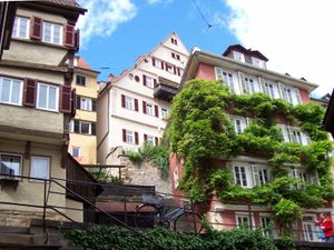
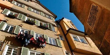
Der dortige, ruhige Bereich der Altstadt - ihre steile, sonnige Südseite - mutet schon fast mediterran an. Mit seinen verwinkelten Gassen, Treppen und alten Häusern (teilweise mit bis zu acht Geschossen beeindruckend hoch) bietet er ein sehr pittoreskes und romantisches Bild.
Über diese Gasse erreicht man den Haupteingang und Vorhof des Stifts, der vom hohen Chor der spätgotischen früheren Kloster- und Stiftskirche und heutigen Hauskapelle überragt wird.
Durch ein Stück original erhaltener Stadtmauer gelangt man hinunter zum Neckarbad. Drei Treppen führen hinauf zur Clinicumsgasse, davon eine besonders malerische und schmale (mit über 60 teils ausgetretenen Stufen) noch weiter bis zur Münzgasse.
Blick vom Neckarbad
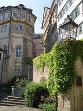
Stiftskapelle und Brunnen am Eingang des Stifts
Hohe Häuser am oberen Klosterberg

Klosterberg in den 1980er Jahren
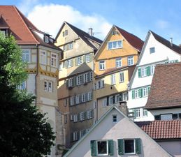
Häuser am Klosterberg

Klosterberg auf einer alten Postkarte


