Einkaufszentrum Wanne
Aus TUEpedia
Einkaufszentrum Wanne | |
|---|---|


Im Einkaufszentrum Wanne an der Hartmeyerstraße gibt es folgende Läden:
- 7: Penny, Supermarkt
- 9: Filiale der Kreissparkasse mit Geldautomat
- 11: Bella Roma, Restaurant
- 11: Café Bäcker Mayer (Wanne)
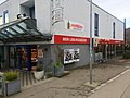
- 11: Schmackes (bis Okt. 2019 war hier die Gärtnerei Hespeler)
Außerdem im Einkaufszentrum Wanne, jedoch postalisch zur Straße Beim Herbstenhof gehörend:
- 3: Postfiliale Wanne im Einzelhandel Charonsouk
- 5: Physio Wanne
- 7: bis 2019: Metzgerei Schneider
- 9: Bati Markt
- 9: Friseur Salon Kern
- 11: Schönbuch-Apotheke
- bitte erg.
Bilder[Bearbeiten | Quelltext bearbeiten]

Filiale der Kreissparkasse

Friseur Salon Kern

Schönbuch-Apotheke
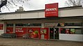
Filiale Penny Supermarkt

ehem. Filiale Metzgerei Schneider
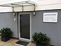
Physio Wanne

Lebenmittelmarkt Schmackes
Filiale Café Bäcker Mayer


