| Im SchloßGeo-Cache leeren | |
|---|---|
Die Karte wird geladen … {"minzoom":false,"maxzoom":false,"mappingservice":"leaflet","width":"auto","height":"350px","centre":false,"title":"","label":"","icon":"","lines":[],"polygons":[],"circles":[],"rectangles":[],"copycoords":false,"static":false,"zoom":false,"defzoom":14,"layers":["OpenStreetMap"],"image layers":[],"overlays":[],"resizable":false,"fullscreen":false,"scrollwheelzoom":true,"cluster":false,"clustermaxzoom":20,"clusterzoomonclick":true,"clustermaxradius":80,"clusterspiderfy":true,"geojson":{"type":"FeatureCollection","features":[{"type":"Feature","properties":{"stroke-width":5,"stroke-opacity":0.7},"geometry":{"type":"LineString","coordinates":[[9.0596004,48.5611096],[9.0596676,48.5610919],[9.0601895,48.5609786],[9.0602721,48.56097],[9.0604316,48.5609622],[9.0605422,48.5609673],[9.0606076,48.5610089],[9.0607122,48.5610543],[9.0607896,48.5610765]]}},{"type":"Feature","properties":{"stroke-width":1},"geometry":{"type":"Polygon","coordinates":[[[9.061106,48.5611148],[9.0611224,48.5609817],[9.0611662,48.5609813],[9.0613276,48.5609799],[9.0613257,48.5609929],[9.0613169,48.5610527],[9.061313,48.5610796],[9.0613046,48.5611283],[9.061106,48.5611148]]]}},{"type":"Feature","properties":{"stroke-width":1},"geometry":{"type":"Polygon","coordinates":[[[9.0611545,48.5615075],[9.0611528,48.5614822],[9.0610086,48.5614851],[9.0609935,48.5615225],[9.060998,48.5616089],[9.0610017,48.5617242],[9.0610097,48.5618027],[9.0611686,48.5617991],[9.0611677,48.5617697],[9.0611634,48.5617129],[9.0611599,48.5616599],[9.0611599,48.5615967],[9.0611545,48.5615075]]]}},{"type":"Feature","properties":{"stroke-width":1},"geometry":{"type":"Polygon","coordinates":[[[9.0613046,48.5611283],[9.061313,48.5610796],[9.0614484,48.5610925],[9.0614968,48.5610971],[9.0614323,48.5614275],[9.0612472,48.5614113],[9.0612544,48.5613782],[9.0612754,48.5612714],[9.0612552,48.5612696],[9.0612605,48.5612457],[9.0612653,48.5612217],[9.061285,48.5612231],[9.0613046,48.5611283]]]}},{"type":"Feature","properties":{"stroke-width":1},"geometry":{"type":"Polygon","coordinates":[[[9.0608911,48.5613233],[9.0609128,48.5611341],[9.0609198,48.5610728],[9.060913,48.5610773],[9.0608858,48.5610766],[9.0608746,48.5610662],[9.0608756,48.5610561],[9.060877,48.5610428],[9.0608916,48.561036],[9.0609151,48.5610369],[9.0609242,48.5610446],[9.0609332,48.5609785],[9.0611224,48.5609817],[9.061106,48.5611148],[9.0611031,48.5611376],[9.0610832,48.5612936],[9.0610942,48.5612942],[9.0610902,48.5613246],[9.0610781,48.5613239],[9.0610768,48.5613334],[9.0608911,48.5613233]]]}},{"type":"Feature","properties":{"stroke-width":1},"geometry":{"type":"Polygon","coordinates":[[[9.0606707,48.5616252],[9.0606622,48.561675],[9.0606917,48.5616767],[9.0607246,48.561659],[9.0607348,48.5616667],[9.0607012,48.5616851],[9.060701,48.5616904],[9.0607287,48.5617032],[9.0607239,48.5617368],[9.0606912,48.561746],[9.0606904,48.5617515],[9.0607176,48.5617733],[9.0607056,48.5617802],[9.060678,48.5617573],[9.0606101,48.5617528],[9.0606014,48.5618045],[9.0605803,48.5618032],[9.0605775,48.5618174],[9.0604567,48.5618106],[9.0604574,48.5618045],[9.0604399,48.5618033],[9.0604409,48.5617926],[9.0604021,48.5617901],[9.0604005,48.5617999],[9.0603776,48.5617983],[9.0603792,48.5617885],[9.0603386,48.5617858],[9.0603369,48.5617957],[9.0603144,48.561794],[9.0603161,48.5617841],[9.060272,48.5617816],[9.0602488,48.5617891],[9.0602344,48.5617736],[9.0602658,48.5617635],[9.0602719,48.5617237],[9.0602506,48.5617227],[9.0602528,48.5617074],[9.060274,48.5617087],[9.0602801,48.5616496],[9.0602589,48.5616483],[9.0602613,48.5616329],[9.0602813,48.5616339],[9.0602867,48.5615996],[9.0605025,48.5616139],[9.0606707,48.5616252]]]}},{"type":"Feature","properties":{"stroke-width":1},"geometry":{"type":"Polygon","coordinates":[[[9.0604409,48.5612445],[9.0604439,48.5612263],[9.0604646,48.5612275],[9.0604663,48.5612138],[9.060446,48.5612127],[9.0604523,48.5611749],[9.0604731,48.5611762],[9.0604745,48.561162],[9.0604546,48.5611608],[9.0604571,48.5611455],[9.0604613,48.5611194],[9.0604819,48.5611205],[9.0604839,48.5611054],[9.0604637,48.5611042],[9.0604697,48.5610674],[9.0604899,48.5610689],[9.0604921,48.5610548],[9.0604719,48.5610534],[9.0604769,48.5610223],[9.0604964,48.5610127],[9.0604858,48.5610032],[9.0604636,48.5610144],[9.0604425,48.5610127],[9.0604438,48.5610006],[9.0604248,48.5609995],[9.060423,48.5610115],[9.0603632,48.5610074],[9.0603647,48.5609952],[9.0603469,48.5609941],[9.0603452,48.5610057],[9.0603074,48.5610037],[9.060293,48.5609907],[9.0602771,48.5609989],[9.0602909,48.5610098],[9.0602878,48.5610283],[9.0602703,48.5610271],[9.0602679,48.5610412],[9.0602854,48.5610419],[9.0602796,48.5610792],[9.060262,48.5610782],[9.0602595,48.5610936],[9.0602773,48.5610947],[9.0602706,48.5611331],[9.0602555,48.5612315],[9.0604409,48.5612445]]]}}]},"clicktarget":"","GeoJsonSource":null,"GeoJsonRevisionId":null,"imageLayers":[],"locations":[],"imageoverlays":null} | |
| Erschließungsweg | |
| Oberfläche | unhewn_cobblestone |
| Beleuchtet | ja |
| Cache leeren | |
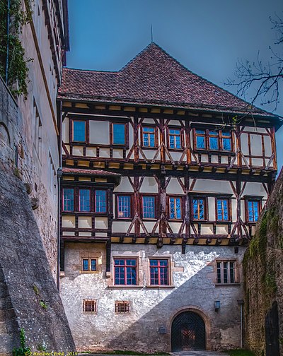
Im Schloß ist ein Weg innerhalb des Kloster- und Schlossareals von Bebenhausen, der zum ehemaligen Schlossteil führt.
Abgerufen von „https://www.tuepedia.de/index.php?title=Im_Schloß&oldid=77494“


