| SalzstadelgasseGeo-Cache leeren | |
|---|---|
Die Karte wird geladen … {"minzoom":false,"maxzoom":false,"mappingservice":"leaflet","width":"auto","height":"350px","centre":false,"title":"","label":"","icon":"","lines":[],"polygons":[],"circles":[],"rectangles":[],"copycoords":false,"static":false,"zoom":false,"defzoom":14,"layers":["OpenStreetMap"],"image layers":[],"overlays":[],"resizable":false,"fullscreen":false,"scrollwheelzoom":true,"cluster":false,"clustermaxzoom":20,"clusterzoomonclick":true,"clustermaxradius":80,"clusterspiderfy":true,"geojson":{"type":"FeatureCollection","features":[{"type":"Feature","properties":{"stroke-width":5,"stroke-opacity":0.7},"geometry":{"type":"LineString","coordinates":[[9.0506642,48.5218508],[9.0506634,48.5218179],[9.0506312,48.5216495],[9.0506253,48.5215606],[9.050634,48.5214364],[9.0506677,48.5212885]]}},{"type":"Feature","properties":{"stroke-width":5,"stroke-opacity":0.7},"geometry":{"type":"LineString","coordinates":[[9.050673,48.5222199],[9.0506642,48.5218508]]}},{"type":"Feature","properties":{"stroke-width":1},"geometry":{"type":"Polygon","coordinates":[[[9.0505224,48.5220796],[9.0506327,48.5220768],[9.0506279,48.522],[9.0505119,48.5220044],[9.0505224,48.5220796]]]}},{"type":"Feature","properties":{"stroke-width":1},"geometry":{"type":"Polygon","coordinates":[[[9.0508325,48.5216379],[9.0506833,48.5216382],[9.0506816,48.5215641],[9.0508353,48.5215644],[9.0508325,48.5216379]]]}},{"type":"Feature","properties":{"stroke-width":1},"geometry":{"type":"Polygon","coordinates":[[[9.0504654,48.5218755],[9.0503759,48.5218792],[9.0503738,48.5218437],[9.0503975,48.521833],[9.0504629,48.5218328],[9.0504654,48.5218755]]]}},{"type":"Feature","properties":{"stroke-width":1},"geometry":{"type":"Polygon","coordinates":[[[9.0505135,48.5219815],[9.050646,48.5219699],[9.0506405,48.521886],[9.0504996,48.5218987],[9.0505135,48.5219815]]]}},{"type":"Feature","properties":{"stroke-width":1},"geometry":{"type":"Polygon","coordinates":[[[9.0504422,48.5216336],[9.050555,48.5216287],[9.0505501,48.5215693],[9.0504143,48.5215652],[9.0504142,48.5215847],[9.0504391,48.5215846],[9.0504422,48.5216336]]]}},{"type":"Feature","properties":{"stroke-width":1},"geometry":{"type":"Polygon","coordinates":[[[9.0503637,48.5219889],[9.0503618,48.5219793],[9.0503777,48.5219771],[9.0503623,48.5219078],[9.0504996,48.5218987],[9.0505135,48.5219815],[9.0503637,48.5219889]]]}},{"type":"Feature","properties":{"stroke-width":1},"geometry":{"type":"Polygon","coordinates":[[[9.0505698,48.5214947],[9.0504542,48.5214848],[9.0504797,48.521385],[9.0505986,48.5214013],[9.0505698,48.5214947]]]}},{"type":"Feature","properties":{"stroke-width":1},"geometry":{"type":"Polygon","coordinates":[[[9.0504039,48.5215649],[9.0504143,48.5215652],[9.0505501,48.5215693],[9.050572,48.5214983],[9.0504128,48.5214855],[9.0504123,48.5214838],[9.0504023,48.5214841],[9.0504039,48.5215649]]]}},{"type":"Feature","properties":{"stroke-width":1},"geometry":{"type":"Polygon","coordinates":[[[9.0507165,48.5221032],[9.0507204,48.5220368],[9.0508165,48.5220329],[9.0508315,48.5220986],[9.0507972,48.522101],[9.0507165,48.5221032]]]}},{"type":"Feature","properties":{"stroke-width":1},"geometry":{"type":"Polygon","coordinates":[[[9.0507204,48.5220368],[9.0507278,48.5219658],[9.0508066,48.5219607],[9.0508165,48.5220329],[9.0507204,48.5220368]]]}},{"type":"Feature","properties":{"stroke-width":1},"geometry":{"type":"Polygon","coordinates":[[[9.0505885,48.5218406],[9.0505793,48.5217903],[9.0503938,48.521797],[9.0503975,48.521833],[9.0504629,48.5218328],[9.0504956,48.5218331],[9.0504973,48.5218486],[9.0505885,48.5218406]]]}},{"type":"Feature","properties":{"stroke-width":1},"geometry":{"type":"Polygon","coordinates":[[[9.0505793,48.5217903],[9.0505756,48.5217501],[9.0503871,48.5217593],[9.0503938,48.521797],[9.0505793,48.5217903]]]}}]},"clicktarget":"","GeoJsonSource":null,"GeoJsonRevisionId":null,"imageLayers":[],"locations":[],"imageoverlays":null} | |
| living_street | |
| Oberfläche | Asphalt, Pflasterstein |
| Beleuchtet | ja |
| Cache leeren | |

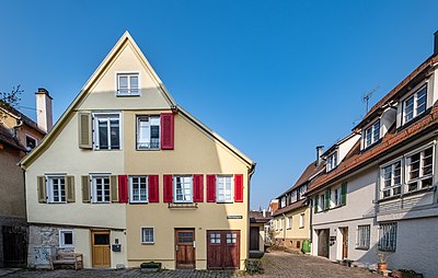
Häuser 9 und 11 (unter gemeinsamen Dach), gesehen von der Madergasse

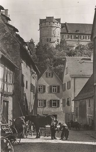
Schmied in der Salzstadelgasse
Die Salzstadelgasse ist eine Gasse in der Unterstadt der Tübinger Altstadt.
Sie verläuft in Nord-Süd-Richtung auf ca. 100 m Länge von der Straße Am Kleinen Ämmerle zu der Jakobsgasse im Süden. An ihr liegt das Salzstadel.
Versteckte Kategorien:
