| GeorgstraßeGeo-Cache leeren | |
|---|---|
Die Karte wird geladen … {"minzoom":false,"maxzoom":false,"mappingservice":"leaflet","width":"auto","height":"350px","centre":false,"title":"","label":"","icon":"","lines":[],"polygons":[],"circles":[],"rectangles":[],"copycoords":false,"static":false,"zoom":false,"defzoom":14,"layers":["OpenStreetMap"],"image layers":[],"overlays":[],"resizable":false,"fullscreen":false,"scrollwheelzoom":true,"cluster":false,"clustermaxzoom":20,"clusterzoomonclick":true,"clustermaxradius":80,"clusterspiderfy":true,"geojson":{"type":"FeatureCollection","features":[{"type":"Feature","properties":{"stroke-width":5,"stroke-opacity":0.7},"geometry":{"type":"LineString","coordinates":[[9.0443418,48.5245271],[9.0443597,48.5238778],[9.0443791,48.523071]]}},{"type":"Feature","properties":{"stroke-width":1},"geometry":{"type":"Polygon","coordinates":[[[9.0441976,48.5236744],[9.044202,48.5235654],[9.044312,48.5235673],[9.0443076,48.5236764],[9.0441976,48.5236744]]]}},{"type":"Feature","properties":{"stroke-width":1},"geometry":{"type":"Polygon","coordinates":[[[9.0444674,48.523538],[9.0444708,48.5234704],[9.0445905,48.523473],[9.0445895,48.5234941],[9.04463,48.523495],[9.0446277,48.5235415],[9.0444674,48.523538]]]}},{"type":"Feature","properties":{"stroke-width":1},"geometry":{"type":"Polygon","coordinates":[[[9.0441054,48.5238248],[9.0441007,48.5237285],[9.0443039,48.5237324],[9.044301,48.5238085],[9.0442817,48.5238208],[9.0442353,48.5238218],[9.0442354,48.5238231],[9.0441693,48.5238246],[9.0441692,48.5238233],[9.0441054,48.5238248]]]}},{"type":"Feature","properties":{"stroke-width":1},"geometry":{"type":"Polygon","coordinates":[[[9.0442142,48.5233405],[9.044218,48.5232583],[9.0441702,48.5232573],[9.0441729,48.5231991],[9.0443308,48.5232023],[9.0443242,48.5233428],[9.0442142,48.5233405]]]}},{"type":"Feature","properties":{"stroke-width":1},"geometry":{"type":"Polygon","coordinates":[[[9.0444599,48.5236633],[9.0444649,48.5235657],[9.0446686,48.5235698],[9.0446613,48.5236681],[9.0444599,48.5236633]]]}},{"type":"Feature","properties":{"stroke-width":1},"geometry":{"type":"Polygon","coordinates":[[[9.0444708,48.5234704],[9.0444758,48.5233894],[9.044595,48.5233926],[9.0445928,48.5234281],[9.0446097,48.5234285],[9.0446079,48.5234592],[9.0445905,48.5234588],[9.0445905,48.523473],[9.0444708,48.5234704]]]}},{"type":"Feature","properties":{"stroke-width":1},"geometry":{"type":"Polygon","coordinates":[[[9.0444643,48.5233508],[9.0444687,48.5231918],[9.0446005,48.5231934],[9.0445985,48.5232673],[9.044598,48.5232824],[9.0445971,48.5233161],[9.0445961,48.5233524],[9.0444643,48.5233508]]]}},{"type":"Feature","properties":{"stroke-width":1},"geometry":{"type":"Polygon","coordinates":[[[9.0440786,48.524087],[9.0440768,48.5241358],[9.0441271,48.5241367],[9.0441262,48.5241604],[9.0442842,48.5241631],[9.0442869,48.5240905],[9.0440786,48.524087]]]}},{"type":"Feature","properties":{"stroke-width":1},"geometry":{"type":"Polygon","coordinates":[[[9.0444386,48.5241522],[9.0444347,48.5242473],[9.0445572,48.5242494],[9.0445611,48.5241544],[9.0444386,48.5241522]]]}},{"type":"Feature","properties":{"stroke-width":1},"geometry":{"type":"Polygon","coordinates":[[[9.0441466,48.5241969],[9.0442823,48.5241996],[9.0442794,48.5242631],[9.0441436,48.5242603],[9.0441466,48.5241969]]]}},{"type":"Feature","properties":{"stroke-width":1},"geometry":{"type":"Polygon","coordinates":[[[9.0444321,48.5243007],[9.0445481,48.5243027],[9.0445449,48.5243665],[9.0445632,48.5243856],[9.0444623,48.5244248],[9.044427,48.5244107],[9.0444321,48.5243007]]]}},{"type":"Feature","properties":{"stroke-width":1},"geometry":{"type":"Polygon","coordinates":[[[9.0441614,48.5230564],[9.0441677,48.5229684],[9.0442933,48.5229739],[9.0442892,48.523057],[9.0441614,48.5230564]]]}},{"type":"Feature","properties":{"stroke-width":1},"geometry":{"type":"Polygon","coordinates":[[[9.0444541,48.5231441],[9.0444567,48.5230509],[9.0446081,48.5230527],[9.0446056,48.523146],[9.0444541,48.5231441]]]}},{"type":"Feature","properties":{"stroke-width":1},"geometry":{"type":"Polygon","coordinates":[[[9.0441905,48.5235238],[9.0441954,48.5234419],[9.0443184,48.5234445],[9.0443143,48.5235256],[9.0441905,48.5235238]]]}},{"type":"Feature","properties":{"stroke-width":1},"geometry":{"type":"Polygon","coordinates":[[[9.0441954,48.5234419],[9.0441961,48.5234283],[9.0441005,48.5234238],[9.0441055,48.5233746],[9.0441539,48.5233769],[9.0441624,48.5233761],[9.0441989,48.5233693],[9.0443219,48.5233719],[9.0443184,48.5234445],[9.0441954,48.5234419]]]}},{"type":"Feature","properties":{"stroke-width":1},"geometry":{"type":"Polygon","coordinates":[[[9.044152,48.5244453],[9.0441563,48.5243598],[9.0442742,48.524362],[9.0442703,48.5244548],[9.0441644,48.5244522],[9.044152,48.5244453]]]}}]},"clicktarget":"","GeoJsonSource":null,"GeoJsonRevisionId":null,"imageLayers":[],"locations":[],"imageoverlays":null} | |
| Anliegerstraße | |
| Oberfläche | Asphalt |
| Höchstgeschwindigkeit | 30 km/h |
| Beleuchtet | ja |
| Bürgersteig | beidseitig |
| Cache leeren | |

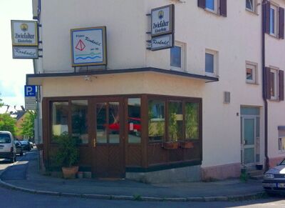
Ehemalige Pilsbar Krokodil am Nil, heute Cum Tempore, Georgstraße 1
Die Georgstraße in der Weststadt beginnt an der Stöcklestraße und verläuft von dort nach Süden, bis sie kurz vor der Ammer für Autos als Sackgasse endet. Aber ein Durchgang führt weiter zu dem Fuß- und Radweg, der entlang der Ammer verläuft. In etwa der Mitte der Wohnstraße wird die Herrenberger Straße gekreuzt.
An der Ecke zur Stöcklestraße liegt die Trinkstube Cum Tempore, früher Krokodil am Nil.
Abgerufen von „https://www.tuepedia.de/index.php?title=Georgstraße&oldid=67392“
Versteckte Kategorien: